Slang's Anti-Singularity
  • Slanghome
  • Slangblog
  • Slangpuzzles
    • CurrentPuzzles
    • ScholarPuzzle
    • PastPuzzles

Moving Ahead With RunningAhead

6/8/2012

0 Comments

 
Run data, run data, run data. When will it EVER end? Probably with this post, is my guess. After this, well, I think I may stop harping about it, and simply enjoy the time outdoors and not worry about elevation profiles.

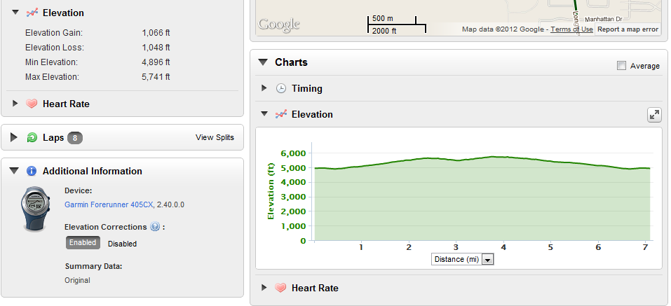
I recently started putting my run data on RunningAhead.com. I really like the site and the ability to graph multiple elements simultaneously on a single graph. I also like that it reads the data from my Garmin Forerunner 405CX wirelessly, too. That makes data upload easy. The only thing Garmin has on their site that I still occasionally look at is goal-progress. I imagine RA can implement that one pretty easily too, and eliminate any need for me to deal with Garmin.

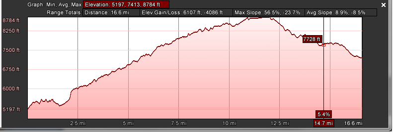
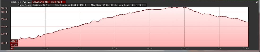
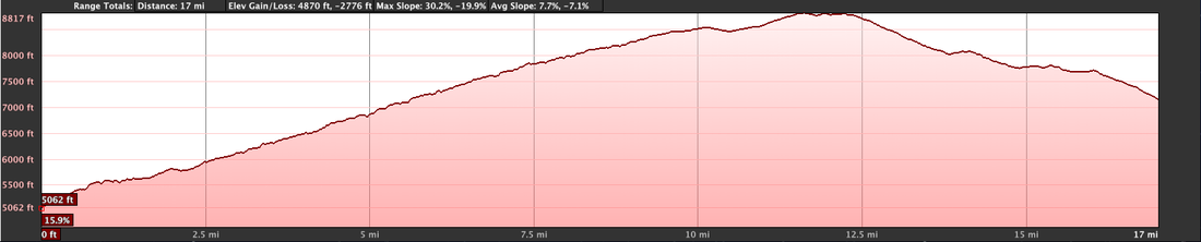
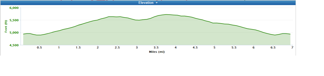
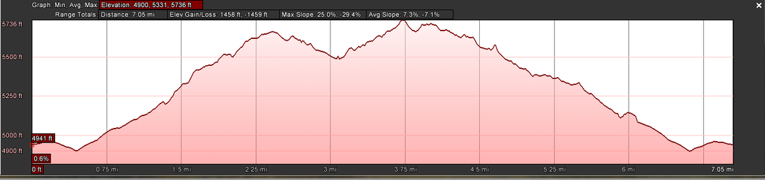
When I uploaded some of my data, I noticed that, yet again, the elevation profile information was different from everyone else's. As part of a different conversation with Eric Yee from RunningAhead, I asked about why there were differences in elevation profiles for different sites. This is part of his response:

"It all depends on how the points are sampled.  The elevation data are sampled differently depending on location.  On RA, the entire country is sampled at every 30 meters.  Some parts of the country also have 10 meter samples.  The software will always choose the the highest resolution sample to use.

As you said in your blog, the points are expressed as a series of lat lng points.  Since the elevation sampling is in a grid, most of the points do not fall directly on the sampling point so some interpolation is needed.  This where where the difference between difference sites come from because each site will have a different interpolation algorithm.  Sites such as RA and Garmin tend to have reproducible elevation profiles (within each site) because all the servers use the same algorithm.

Google is different.  The reason you get a different profile depending on the computer you're using is that Google does a lot of things behind the scenes.  Depending on a bunch of factors such as your computer's geographic location, OS, and who knows what else, your request will be load balanced differently.  To make it more complicated, Google also do A/B test with their users so what you see will be different from what someone else is seeing.  Depending on which server is handling your request, it may have a different algorithm because it takes time for the software to be deployed across Google's network. "


Wow. Google is different. I also think there is a fudge factor at play on some of my runs in the data itself. If, for example I am following a trail on the side of a fairly steep hill, the trail may be in fact "flat" as it is following the contour. However, the GPS is not ever spot on, and it may be tracking a point 20 feet to the right, then 5 feet to the left, and so on. On a steep hillside, that 20' right might be 15 feet higher than I am, and the 5' to the left may be 10 feet down. So in the course of my movement of 10 feet straight ahead, and level, the GPS just might have tracked a 30' loss of elevation. Or so it seems to me.

At any rate, have a great weekend. My loin-fruit are free of school as of this afternoon, so they'll be as happy as I am tomorrow: they get to sleep in, and I get to go for a run before the big 13th birthday party for my son. O_O
0 Comments

Reality distortion field

5/31/2012

0 Comments

 
I use Google Earth a lot to view places, plan runs and create elevation profiles for the entries in this blog. While I was putting together the latest run entry, I noticed something odd about the elevation profile information. It changed. The same kmz file provided different elevation profiles -CONSTANTLY. I looked at the run on a Mac, and then on a PC. Different. I looked at the run on the PC at different window sizes. Different again for each window width, for both distance, and elevation gain/loss.

I don't get it. The data are a series of XML latitude and longitude points. The earth itself doesn't change based on the viewer used to see it (boy, that would be weird), so why would the elevation profile change between what is used to look at it? I guess there is no way to truly extract the accurate elevation profile information from any of the tools I have access to, considering there is a difference in Garmin's interpretation of their own data when the information is presented on their website as either a route or a course.

Google Earth: a reality distortion field. In this case, if I wanted my elevation profile to appear to be more of a challenge, I simply stretch the X-axis of the graph by increasing the width of the window and it happily accommodates me, making both the distance and the elevation changes appear greater on the screen. Selecting "Get Info"/"Properties" on the file in the places list and then selecting the Measurements tab shows the same for the length, so at least that seems to be static. 

The data from the run is shown in the following images, with the screen grabs from the same kmz file. I wonder if it is simply a factor of revealing more information, thus making the wider view the more accurate view? I don't know, but I would be interested to find out. 
Picture
Compressed PC view
Picture
Stretched PC view
Picture
Macintosh view
0 Comments

Run data slicing and dicing

5/22/2012

0 Comments

 
When I run, I usually tote along my Garmin Forerunner 405CX in order to keep track of the miles trod, and to capture the information into courses and routes for others to (potentially) follow if it turns out to be a good one. Since not everyone uses Garmin products and may not want to use the Garmin website's courses feature, I also convert the GPS data to Google Earth and post all the information into a .kmz file (scroll to the download link) for viewing in Google Earth on a local pc.

The data is the same: XML data containing latitude and longitude and that's about it. When it gets to either the Garmin website and/or Google Earth, that data is interpreted over maps to give the user a visual look of the data rather than lat/long coordinates, and gives distance, and elevation profile. This is where it gets all divergent.

I did a run last Friday that I converted to a course. The base run data as uploaded is shown below (Sorry, you don't get to see my imminent heart attack displayed in the heart rate info, nor the "trudge factor" in the timing chart.):
Picture
When I elected to save the run as a course, the data changed! Instead of being over 7 miles, the course data was 6.95, though the elevation data remained the same with a gain of 1066 feet. However, I do like that the elevation profile no longer starts at sea level, making the 1000+ elevation gain almost look like it hurt as much as it did.
Picture
In addition to saving the run as a course, I used the Garmin function to export the data to a Google Earth file. This conversion results in yet another divergent data set. In this case, the run distance shows as 7.05 miles, which isn't too terribly off (only 1 %) from the base run data, but a big delta shows up in the elevation gain: 1458 feet. Wow. That's a 37% difference! I must admit I much prefer the look of a Google Earth elevation profile over either Garmin:
Picture
Just looking at the elevation profiles, I get the feeling that Garmin is smoothing the data that erases the small changes in elevation despite using Google as the mapping base. However, over the course of a longer run, the tiny smoothing changes the overall run a lot. Those three and five foot elevation changes on the trail add up. Tell me. Toward the end of a run, any little hill up -- only to go back down -- gets a sound round of cursing from me.
0 Comments

Privacy? Probably not, but this might help.

2/24/2012

0 Comments

 
I use Google. You use Google. Everybody except Bill Gates (who uses Bing at work, and Google at home) uses Google. Heck, I even call him Uncle Google. Until now, he was the likable, bookworm uncle who in my mind was a museum curator/librarian. Geeky, and shy.

Now, though Uncle Google is the hirsute, balding fat uncle who comes to dinner on holidays and leers at your sister-in-law. 

From the Electronic Frontier Foundation:
"On March 1st, Google will implement its new, unified privacy policy, which will affect data Google has collected on you prior to March 1st as well as data it collects on you in the future. Until now, your Google Web History (your Google searches and sites visited) was cordoned off from Google's other products. This protection was especially important because search data can reveal particularly sensitive information about you, including facts about your location, interests, age, sexual orientation, religion, health concerns, and more. If you want to keep Google from combining your Web History with the data they have gathered about you in their other products, such as YouTube or Google Plus, you may want to remove all items from your Web History and stop your Web History from being recorded in the future."
To opt out, follow these simple instructions: sign in, go to google.com/history, and choose "Remove All Web History." This also revokes your consent to have your search history recorded going forward.  

Unfortunately for some, this will force you to rebuild some searches. For everything, there are trade-offs, I suppose. I can recreate a search easily enough. I don't need anyone knowing I searched for {+squirrels +"silver hammer" +blind +Shakespeare - android +nuts -testicles +shiraz - sirah} just last week.

 I dunno about you, but I'm heading there now to take care of my quasi-privacy.
0 Comments

Big Brother is Corporate

12/1/2011

0 Comments

 
Holy crap. I always knew that using smart phones (Android, iPhones, etc.) can be potentially a problem for anyone who wanted to keep a reasonable modicum of privacy. Then I saw this, and the words "can be potentially" were replaced with "is definitely."
Though I haven't specifically found any references to CIQ on iPhones, do I believe there is something similar? <Puts on tinfoil hat> Probably.
I am stunned by the duplicity and disingenuousness of the perpetrators of the data mining, especially Carrier IQ. Gotta love the quickly generated video of Carrier IQ's CEO standing in his office in shirt sleeves, all "regular guy" claiming--falsely—that their software doesn't capture keystrokes, when it very clearly does as the above video demonstrates. I really found it interesting his eyes kept flicking away from the camera. Isn't that a "tell" of someone lying? Also by taking the low road and attacking Trevor Eckhart (the person who discovered the data mining) by threatening legal action certainly torches any confidence you might have had in the eyes of public opinion. CarrierIQ: definitely evil. 
Google? Well, I'd have to put you in the evil camp, too. Sorry guys, but I find it impossible that you don't know what is going on and it's a load of crap. You're infringing on the privacy of every Android phone user, and if the government doesn't step in and do something to slow it, then we will all know that the mining was done either at the explicit instruction of the boys in Washington, or with the sly wink and nod, knowing they get to root through the goodies whenever they want.
0 Comments

    RSS Feed

    Author

    A never-was endurance runner, and paripetetic wanna-be who is eyeing early retirement with gleeful enthusiasm.


    Follow @slang4201

    Archives

    December 2019
    November 2019
    October 2019
    July 2019
    October 2018
    September 2018
    May 2018
    April 2018
    November 2017
    October 2017
    July 2017
    June 2017
    June 2015
    August 2014
    January 2014
    October 2013
    September 2013
    June 2013
    May 2013
    April 2013
    March 2013
    February 2013
    January 2013
    December 2012
    November 2012
    October 2012
    September 2012
    August 2012
    July 2012
    June 2012
    May 2012
    April 2012
    March 2012
    February 2012
    January 2012
    December 2011
    November 2011
    October 2011
    August 2011
    March 2011
    October 2010
    July 2010
    January 2009
    December 2008
    October 2008

    Categories

    All
    2011
    Alternate Energy
    Android
    Angela Sullivan
    Animals
    Antiques
    Apple
    Ash Canyon
    Astronomy
    AT&T
    Bailout
    Battery
    Bicycling
    Biometrics
    Books
    Carrier Iq
    Carson City
    Centennial
    C Hill
    C-Hill
    Christmas
    Climate
    Clothing
    Coding
    Colorado
    Columbus
    Cramps
    Curiosity
    Dad
    Dardanelles Lake
    Dell
    Dick's Lake
    Dilbert
    Eagle Lake
    Earworms
    Eating Problems
    Eclipse
    Economy
    Education
    Eldorado Canyon
    Energy
    Errors
    Espionage
    Europe 2019
    Evi
    Fallon
    Family
    Fontanillis Lake
    Food
    Garmin
    Geocaching
    Goals
    Google
    Google Earth
    Grouse Lake
    Hiking
    Inov8
    Investing
    Ipad
    Iphone
    Iron Mountain
    Legislatures
    Mac
    Market
    Market Drop
    Mars
    Mctarnahan
    Medicine
    Microsoft Word
    Motivation
    Mountain Biking
    Moving Minutes
    Music
    Nevada Day
    Nfc
    Ohio
    Olympics
    Openoffice
    Opportunity
    Panama 2018
    Paper Airplane
    People
    Politics
    Prison Hill
    Privacy
    Puts
    Puzzles
    Race
    Rant
    Reno
    Retrospective
    Roosevelt
    Running
    Running Dynamics
    Saddest Cities
    Safe & Sober
    Science
    Shoes
    Shopping
    Sierra
    Sierra Canyon
    Snl
    Soccer
    Software
    Spasms
    Spirit
    Sullivan Canyon
    Svn
    Tahoe
    Tahoe Rim Trail
    Taxes
    Technology
    Transit
    Travel
    Trees
    Vba
    Velma Lakes
    Venus
    Verizon
    Violin
    Watches
    Weather
    Wolframalpha
    Words
    Wrestling
    Writing
    Xkcd
    Yawbe
    Yoga

This is ALL MINE, I tell you! copyright 2010-2020