When I run, I usually tote along my Garmin Forerunner 405CX in order to keep track of the miles trod, and to capture the information into courses and routes for others to (potentially) follow if it turns out to be a good one. Since not everyone uses Garmin products and may not want to use the Garmin website's courses feature, I also convert the GPS data to Google Earth and post all the information into a .kmz file (scroll to the download link) for viewing in Google Earth on a local pc.
The data is the same: XML data containing latitude and longitude and that's about it. When it gets to either the Garmin website and/or Google Earth, that data is interpreted over maps to give the user a visual look of the data rather than lat/long coordinates, and gives distance, and elevation profile. This is where it gets all divergent.
I did a run last Friday that I converted to a course. The base run data as uploaded is shown below (Sorry, you don't get to see my imminent heart attack displayed in the heart rate info, nor the "trudge factor" in the timing chart.):
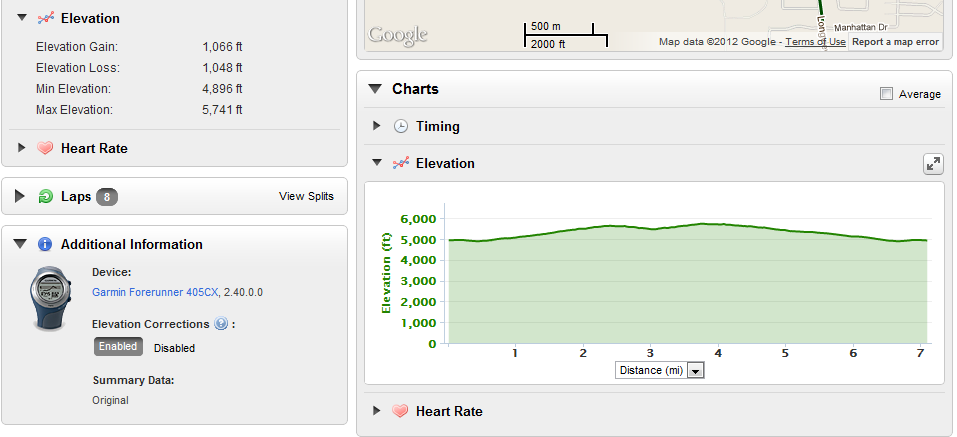
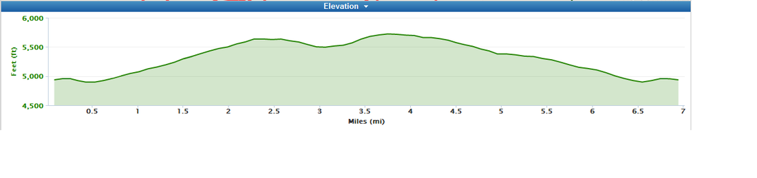
When I elected to save the run as a course, the data changed! Instead of being over 7 miles, the course data was 6.95, though the elevation data remained the same with a gain of 1066 feet. However, I do like that the elevation profile no longer starts at sea level, making the 1000+ elevation gain almost look like it hurt as much as it did.
In addition to saving the run as a course, I used the Garmin function to export the data to a Google Earth file. This conversion results in yet another divergent data set. In this case, the run distance shows as 7.05 miles, which isn't too terribly off (only 1 %) from the base run data, but a big delta shows up in the elevation gain: 1458 feet. Wow. That's a 37% difference! I must admit I much prefer the look of a Google Earth elevation profile over either Garmin:
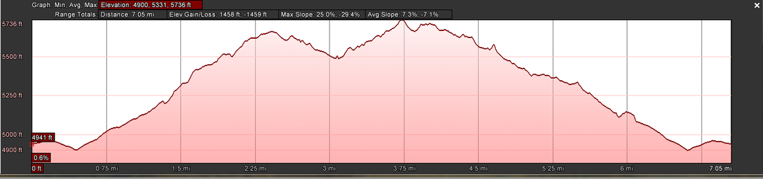
Just looking at the elevation profiles, I get the feeling that Garmin is smoothing the data that erases the small changes in elevation despite using Google as the mapping base. However, over the course of a longer run, the tiny smoothing changes the overall run a lot. Those three and five foot elevation changes on the trail add up. Tell me. Toward the end of a run, any little hill up -- only to go back down -- gets a sound round of cursing from me.
 RSS Feed