Slang's Anti-Singularity
  • Slanghome
  • Slangblog
  • Slangpuzzles
    • CurrentPuzzles
    • ScholarPuzzle
    • PastPuzzles

Run data slicing and dicing

5/22/2012

0 Comments

 
When I run, I usually tote along my Garmin Forerunner 405CX in order to keep track of the miles trod, and to capture the information into courses and routes for others to (potentially) follow if it turns out to be a good one. Since not everyone uses Garmin products and may not want to use the Garmin website's courses feature, I also convert the GPS data to Google Earth and post all the information into a .kmz file (scroll to the download link) for viewing in Google Earth on a local pc.

The data is the same: XML data containing latitude and longitude and that's about it. When it gets to either the Garmin website and/or Google Earth, that data is interpreted over maps to give the user a visual look of the data rather than lat/long coordinates, and gives distance, and elevation profile. This is where it gets all divergent.

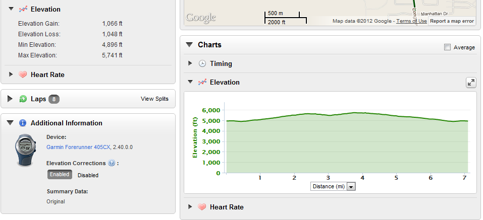
I did a run last Friday that I converted to a course. The base run data as uploaded is shown below (Sorry, you don't get to see my imminent heart attack displayed in the heart rate info, nor the "trudge factor" in the timing chart.):
Picture
When I elected to save the run as a course, the data changed! Instead of being over 7 miles, the course data was 6.95, though the elevation data remained the same with a gain of 1066 feet. However, I do like that the elevation profile no longer starts at sea level, making the 1000+ elevation gain almost look like it hurt as much as it did.
Picture
In addition to saving the run as a course, I used the Garmin function to export the data to a Google Earth file. This conversion results in yet another divergent data set. In this case, the run distance shows as 7.05 miles, which isn't too terribly off (only 1 %) from the base run data, but a big delta shows up in the elevation gain: 1458 feet. Wow. That's a 37% difference! I must admit I much prefer the look of a Google Earth elevation profile over either Garmin:
Picture
Just looking at the elevation profiles, I get the feeling that Garmin is smoothing the data that erases the small changes in elevation despite using Google as the mapping base. However, over the course of a longer run, the tiny smoothing changes the overall run a lot. Those three and five foot elevation changes on the trail add up. Tell me. Toward the end of a run, any little hill up -- only to go back down -- gets a sound round of cursing from me.
0 Comments


Leave a Reply.

    RSS Feed

    Author

    Just a guy out exploring the world. Former world-class never-was endurance runner.

    ​Hit me up, and we'll catch a beer or coffee in your town.


    Follow @slang4201

    Archives

    September 2021
    August 2021
    May 2021
    October 2020
    September 2020
    December 2019
    November 2019
    October 2019
    July 2019
    October 2018
    September 2018
    May 2018
    April 2018
    November 2017
    October 2017
    July 2017
    June 2017
    June 2015
    August 2014
    January 2014
    October 2013
    September 2013
    June 2013
    May 2013
    April 2013
    March 2013
    February 2013
    January 2013
    December 2012
    November 2012
    October 2012
    September 2012
    August 2012
    July 2012
    June 2012
    May 2012
    April 2012
    March 2012
    February 2012
    January 2012
    December 2011
    November 2011
    October 2011
    August 2011
    March 2011
    October 2010
    July 2010
    January 2009
    December 2008
    October 2008

    Categories

    All
    2011
    Alternate Energy
    Android
    Angela Sullivan
    Animals
    Antiques
    Apple
    Ash Canyon
    Astronomy
    AT&T
    Bailout
    Battery
    Bicycling
    Biometrics
    Books
    Carrier Iq
    Carson City
    Centennial
    C Hill
    C-Hill
    Christmas
    Climate
    Clothing
    Coding
    Colorado
    Columbus
    Cramps
    Curiosity
    Dad
    Dardanelles Lake
    Dell
    Dick's Lake
    Dilbert
    Eagle Lake
    Earworms
    Eating Problems
    Eclipse
    Economy
    Education
    Eldorado Canyon
    Energy
    Errors
    Espionage
    Europe 2019
    Evi
    Fallon
    Family
    Fontanillis Lake
    Food
    Garmin
    Geocaching
    Goals
    Google
    Google Earth
    Grouse Lake
    Hiking
    Inov8
    Investing
    Ipad
    Iphone
    Iron Mountain
    Legislatures
    Mac
    Market
    Market Drop
    Mars
    Mctarnahan
    Medicine
    Microsoft Word
    Motivation
    Mountain Biking
    Moving Minutes
    Music
    Nevada Day
    Nfc
    Ohio
    Olympics
    Openoffice
    Opportunity
    Panama 2018
    Paper Airplane
    People
    Politics
    Prison Hill
    Privacy
    Puts
    Puzzles
    Race
    Rant
    Reno
    Retrospective
    Roosevelt
    Running
    Running Dynamics
    Saddest Cities
    Safe & Sober
    Science
    Shoes
    Shopping
    Sierra
    Sierra Canyon
    Slangsploration
    Snl
    Soccer
    Software
    Spasms
    Spirit
    Sullivan Canyon
    Svn
    Tahoe
    Tahoe Rim Trail
    Taxes
    Technology
    Transit
    Travel
    Trees
    Vba
    Velma Lakes
    Venus
    Verizon
    Violin
    Watches
    Weather
    Wolframalpha
    Words
    Wrestling
    Writing
    Xkcd
    Yawbe
    Yoga

This is ALL MINE, I tell you! copyright 2010-2021