Slang's Anti-Singularity
  • Slanghome
  • Slangblog
  • Slangpuzzles
    • CurrentPuzzles
    • ScholarPuzzle
    • PastPuzzles

Footing Don't Fail Me Now

1/28/2013

2 Comments

 
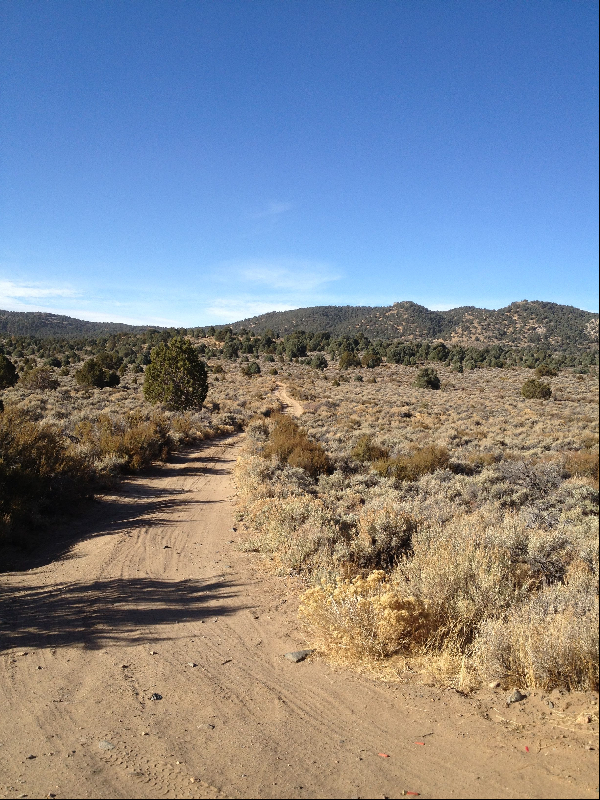
Saturday was a run day for me. I planned to revisit a route I hadn't done in a while, going solo this time. The plan was to drive up the along the east side of McTarnahan from Brunswick Canyon and do 16 - 20K from there. I should have known, what with all the authors I twitterfy these days, that the conditions of my access route should have provided some foreshadowing of what was to come.
Picture
Once there, the routes in the area looked... reasonable. Snow is to be expected in the area in January, despite temperatures finally breaking through to the positive side of average, and shorts being the de rigueur attire for the day.

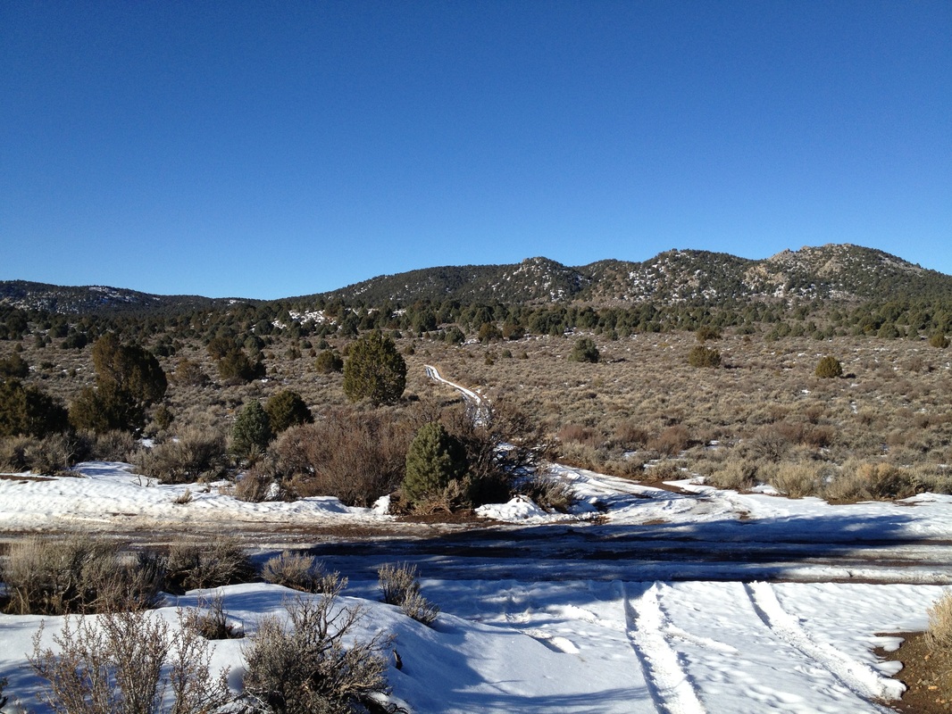
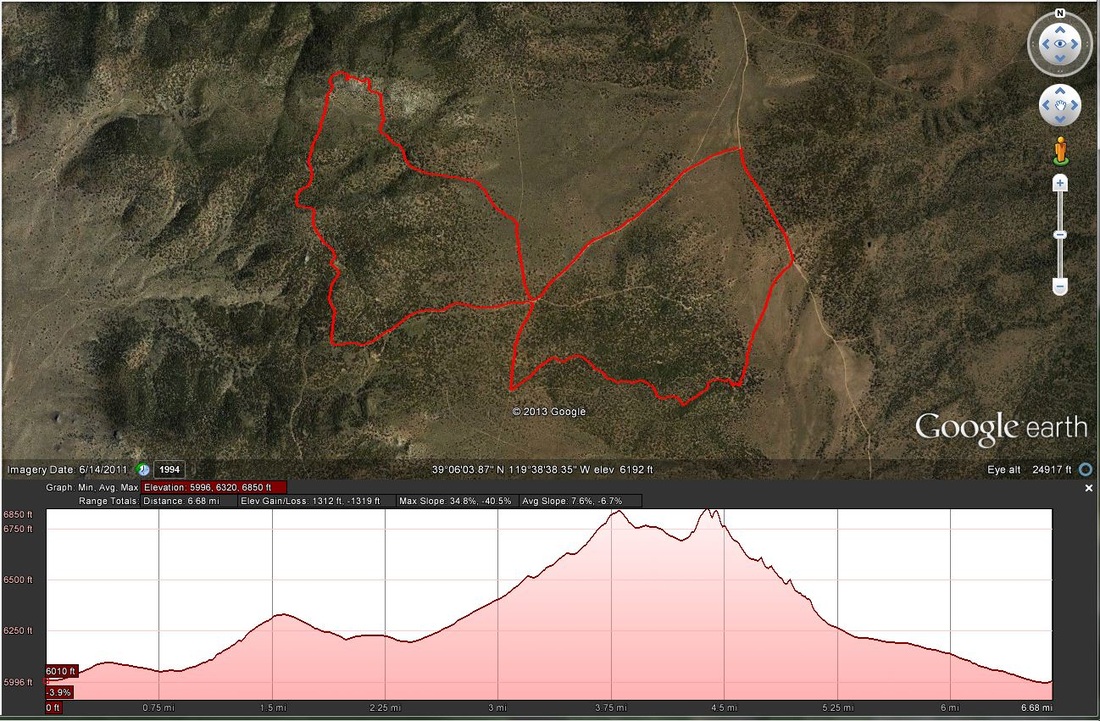
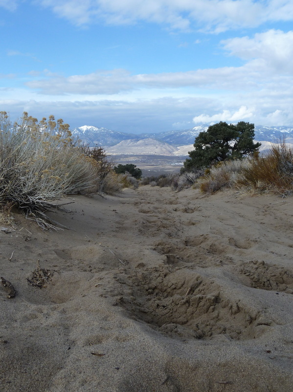
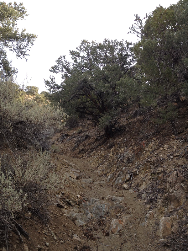
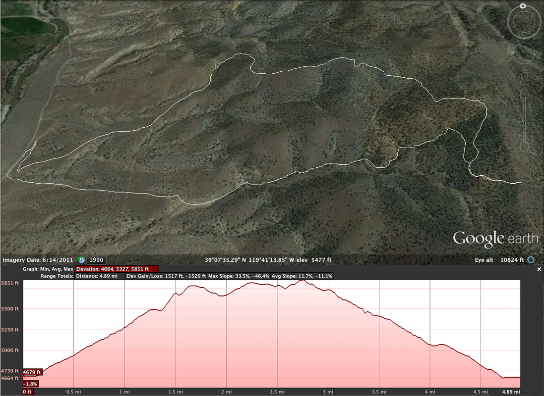
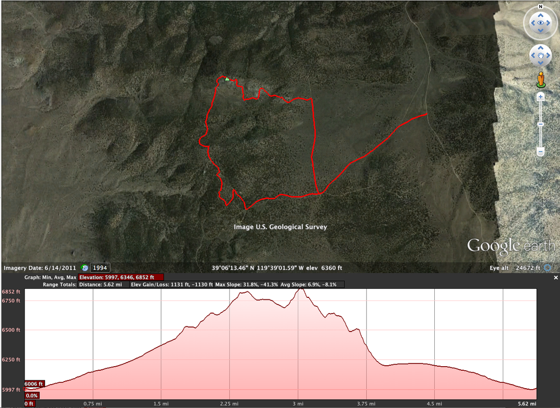
In the photo to the left (click here to see location on map), I was going to make an immediate left, head south for a bit then wind my way via trail back to the road heading straight ahead, then follow the ridge line to the peak to the right and the high point in the run: McTarnahan Hill (route shown at the bottom of the post).

I figured the snow would either be significantly melt-compressed on the trail parts and provide decent footing. On the roads, I'd run the middles with the same conditions or in the drive-ruts for even more compression. Not the best, but not bad either. Wrong.

Picture
After tiptoeing along the smoothly polished ice ruts, I finally got to where I turned off onto the trail and headed southwest toward the trees. I stopped to snap the shot there on the right. It was a beautiful day, and an untracked trail beckoned. Then I got to the trees.

Under the trees, the snow conditions were... challenging. Due to shadows, it hadn't compressed down. It simply had formed a crust. Not just any crust, but a Jesus Fucking Crust. Or so I thought after what seemed hours of it. The crust was just thick enough that it would support my walking weight. Approximately 15% of the time. The rest of the time, it would support me momentarily, then I'd break through. Since I was trying to run (ha!) I'd consistently break through and the front edge would then grab my foot in a really good try at tripping me. Every. Single. Time. Needless to say, it was difficult and demoralizing. I was looking forward to hitting the tracked dirt road again. Even the ice in the ruts was better than this. 

When I finally did (not telling how long it took to get there, neener neener!) I opened my stride for about a minute. Then I hit some mud and slowed. Not bad, doable. Carry on. A few strides further, and it's looking suspicious. Hmm. Snow, but discolored like dirty snow. Could be ice under there, go easy. 

Picture
I move out of the rut to the middle, and hit the snow. Foot goes easily through the top crust, and submerges in the water underneath. Swell. Now I have a soaked foot. Try to leap out of the danger zone. Fail. Other foot hits the disguised puddle and also goes ankle deep. Now I have two soaked feet, conditions are NOT improving and 16K yet to go. Really?

I kept slogging and hit the ridge. Nobody had been there, so it was melt-compressed snow on the south faces, deeper crusted powder on the north. Ugh. This SUCKS!

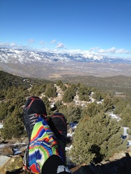
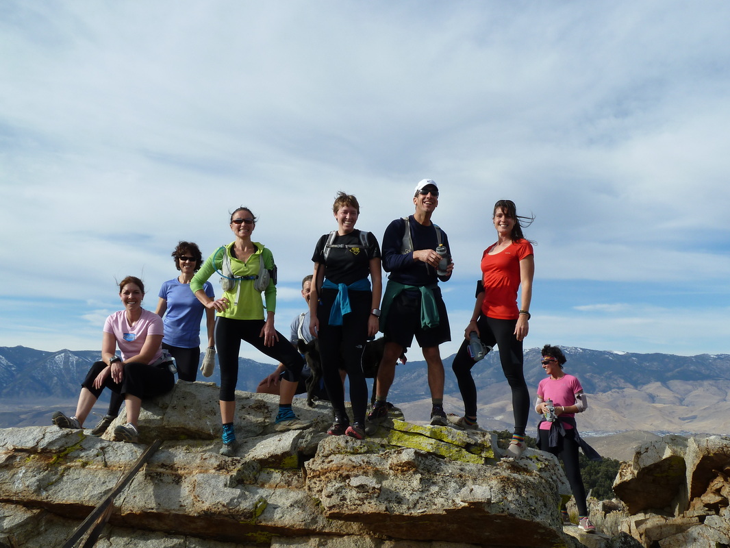
I finally made the top. It was difficult, my feet were numb and the wind had picked up. No surprise there, it's usually breezy on top. I decided to snap a couple pics, and head back by the most direct route, cutting the run nearly in half to 11K. 

I'm not sure for how long my Inov8s and Dirty Girl Gaiters had been planning the photo bomb above, but it worked out well for them. What was going to be a stellar view shot became a color-riot. Oh well. I shot a couple others while keeping a close eye on the photobombers.

Picture
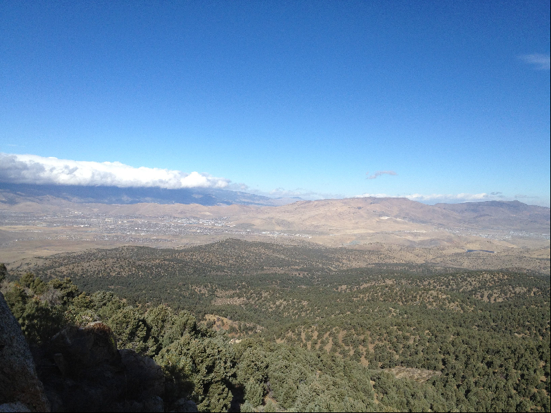
Looking northwest toward Carson City, and Slide Mountain in the distance.
Picture
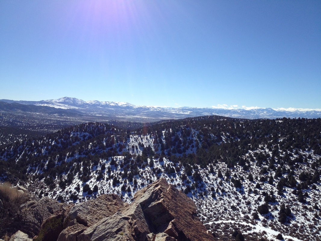
Click to see location on Google Maps.
Picture
About that foreshadowing? Yeah, well driving to the river, I had noticed the road was mostly mud with ice interspersed. At the time, I thought it might be a bit of a challenge to come back out. Even with the 4Runner's hubs locked and in 4-Low, I was sashaying all over the place climbing back out. Truck is a mess now. It's OK, though. I use it mostly for getting to places like this. :-)

I think I'll stay low this weekend. I'm not positive I'll feel the same next week, but right now, I think I'd prefer an overly sandy route.
2 Comments

Mangling well known songs

2/13/2012

2 Comments

 
When I run, I don't wear headphones (a dog attack several years ago cured me of that), but I am a person that likes music. Usually, I get something well known - at least to me - have it rattling about in my head, then change the lyrics to suit whatever is happening. Some highlights from this weekend's activities:
Kate Bush's "Running Up That Hill"  Didn't have to change much of it, except I did substitute "Walking" for "Running" most of the time.
The Beatles' "Hard Day's Night" This one got mangled as follows:
"It was a long downhill, and my IT hurts like hell.
It was a long downhill, and my IT hurts like hell.
But when I get to my car, 
I'll know in my heart,
It really wasn't that far."
That one popped to mind when I was coming off an exploratory activity, looking for a way up to McTarnahan from the west. I did find a route that isn't too bad. The problem for me was on the planned route down, I missed a turn and ended up slogging cross-country, cross-slope, timber bashing through the snow to get to where I thought I was supposed to be. I guess that's what I get for trying to memorize the route and not take a map along. 
The route up was a bit sandy:
Picture
On Sunday, I marked a route far too long for me to run for others to do. I did do a down and back in Sullivan Canyon to mark the turn from Eldorado Canyon, since I couldn't drive it. While descending the canyon early, it was a bit chilly and my nose was running more than usual. That, of course, brought to mind the Bellamy Brothers' classic "Let Your Love Flow" but with the lyrics "Let your snot flow" instead. Fitting.
The rest of the route, I drove to mark. Still, I barely finished ahead of the runners. Fast bunch.
2 Comments

Group run on McTarnahan ends in Deliverance With Dogs

11/28/2011

0 Comments

 
On Sunday, the group conquered McTarnahan. The run up was great: spectacular weather, good trail, only getting lost a couple of times... The only drawback to the entire day was the events that occurred near the end. A subset of the group decided to split off and head back to the vehicles at the 7-mile point. Unfortunately, they headed off into Deliverance With Dogs. They ran across some creep who's been living out there in a ramshackle trailer with 8 dogs for the last seven(!?) years. One of them (a dog) decided Courtney was a delicious morsel and decided to sample. A couple of "nips" later and she had a puncture wound and torn pants. 

Of course, Creepy Guy wanted to "take a look" and decided that Courtney was just "too embarrassed" to let him. Look in the mirror (if you have one) Creepy Guy. I wouldn't let you look at MY leg, and I'm not exactly a young attractive female like Courtney.
Of course Deliverance Man never had had any of his dogs innoculated against anything, so Courtney needed a bit of additional care over and above disinfectant. A rabies shot and (I think) a tetanus shot later, she was good to go. Sorry Courtney. Wish the end of your run could have been as good as the start. :-\

I missed the encounter, and most of the talk with Creepy Guy, but he was at our vehicle when I finally finished. Apparently his truck has hydraulic leaks and he was asking if we had some. He didn't know we were with Courtney & Co. I initially cared about trying to find some fluid, but after hearing about the biting incident and the facts that (a) it wasn't the first time that dog had bit someone, and (b) none of them have had shots, I gave up caring. He could rot out there.

I understand that when Courtney got her medical care, Animal Control and the Carson Sheriff's office were notified. Good. If I am in error regarding what I described above, let me know and I'll modify as needed. I wasn't there for all of , but I was there for parts and the parts I was there for had Dueling Banjos for backdrop music.
Picture
YAY! Summit time!
Picture
Clowning down from the false summit.
Picture
Mike and Liz coming down from the false summit.
Picture
The cars at the junction. Approx a 300mm zoom view from the top.
0 Comments

McTarnahan revisited

11/22/2011

0 Comments

 
Yes, I am taking the week off and having a good time getting out and about. I revisited McTarnahan today as a scouting trip for a group run on Sunday as a post-Thanksgiving fat burner. I found a nice 10 mile loop that had numerous cutouts for shorter distances (5K, 5M, 7M, 8M, 9M). As the weather on top today was much nicer than it was on Friday, I took the time to snap a series of photos which I then stitched together into a 48MB panorama. If you want to take a look, have at it. The location is identified on the map, below. (You'll have to switch to satellite to see anything.)
mctarnahan_summit_panorama.jpg
File Size: 49634 kb
File Type: jpg
Download File

0 Comments

Weekend Jaunts - Sunday

11/21/2011

0 Comments

 
I was very ambitious this weekend. I did a run on Friday in the wind, tried and failed a run on Saturday (made it 1/3 of a mile, got blasted by wind and and sub freezing temps with no potential let up for the entire planned route and wondered "WTF am I doing out here?", gave up and went home), and gave it another go on Sunday.
Of course, I tried to prepare a bit better for Sunday, as it was snowing at my house when I prepped. Three layers, (two on the arms, the full three on the torso) and a hat and gloves. The prospect of snow didn't bother me, and the front had completely passed through on Friday and Saturday, so the potential for much in the way of wind was pretty much nil. 
Again, I decided to try someplace I hadn't been before. I liked McTarnahan Hill on Friday from the east, I thought I would explore approaches to it from the west. I didn't have the intention of summiting — and I didn't, I stopped a few miles short — but the climb was more than the summit achievement two days previous in less distance. Tough, tough climb.
The climb was on a 4x4 road. For a road heading up a canyon and a fairly steep ridge, it was surprisingly un-dug out. The only part of the climb that was tough was the climb itself. Footing was stable, and there were no deep whoop-de-doos to deal with. Of course, pegging the old HR at 165-170 for a 40+ minute climb isn't for everyone. At times, I didn't think it was for me, either. Walking was tough enough in parts, thank you.
Along the way, I found an old, collapsed mine shaft. Pretty cool. 
Picture
I reached the top of a couple of hills, and saw McTarnahan in the distance. I knew I wasn't going to get there on either the energy level or time available, so I bid it adieu with a snappy salute and turned around to head back the way I came. In a very short while, I saw a motorcycle track veering off the road, and decided to take it. Glad I did! It was a blast cruising down that canyon. I wouldn't want to come up that way; it was quite sandy. Taking it as a downhill, though, the sand provided a nice soft surface for my 12 min/mile speed pace. 
The canyon was narrow and twisty and the one photo I did snap doesn't really capture either aspect. Oh well. run it yourself if you want. I think I'll do that one again.
Picture
Below is the route and elevation profile. If you have a hard time distinguishing where to go, contact me and I can give you the Garmin data. Though it appears not, the highest point was at the 
Picture
0 Comments

Weekend Jaunts - Friday

11/21/2011

0 Comments

 
This weekend I had the chance to get out and try a couple new places again. On Friday, after watching the tragic destruction of the Caughlin Ranch Fire in Reno on the television, I headed up Brunswick Canyon to the east of Carson City a bit, parked and started my jaunt to the top of McTarnahan Hill. 
McTarnahan is the tallest point immediately to the east of Carson City. After driving up through Brunswick Canyon, it's not nearly the climb to the top it would be from the west side. Fitting my wimpy self, it was the approach of choice! However the view from the top looking north and west was pretty damn nice. Especially with the storm approaching from the west.
Picture
The route I chose would approach the sadde to the south (on the left in the photo above) and climb up from there. From the top of the northern tip, I first took the photo below, then I went all cross country and busted through the piñon and sage on a generally easterly course until I hit a 4x4 track which brought me back to my approach route. Heading back to the car, I closed the lasso. 
Picture
I didn't spend more time on top than it took to extract my phone from the pack, take the shots and boogie. The wind was pretty strong for the entire run, and was howling on the top. I wasn't wearing appropriate stuff (2 layers, neither windproof), and as a result was freezing in the short time it took to snap the photos. I did cower in the lee of the top rocks while snapping, but was still buffeted about by the wind. I had to retrieve my hat the couple of times it blew off.
This might be a decent winterish run if the snow isn't too bad on this side of the valley. Views are nice, and the trail is good. In fact, the whole top of Brunswick Canyon lends itself to decent running in the cold months. Lots of trails and roads to make any length route you want.
Route and elevation profile of my jaunt below.
Picture
0 Comments

    RSS Feed

    Author

    Just a guy out exploring the world. Former world-class never-was endurance runner.

    ​Hit me up, and we'll catch a beer or coffee in your town.


    Follow @slang4201

    Archives

    August 2022
    July 2022
    June 2022
    May 2022
    April 2022
    March 2022
    February 2022
    January 2022
    December 2021
    November 2021
    October 2021
    September 2021
    August 2021
    May 2021
    October 2020
    September 2020
    December 2019
    November 2019
    October 2019
    July 2019
    October 2018
    September 2018
    May 2018
    April 2018
    November 2017
    October 2017
    July 2017
    June 2017
    June 2015
    August 2014
    January 2014
    October 2013
    September 2013
    June 2013
    May 2013
    April 2013
    March 2013
    February 2013
    January 2013
    December 2012
    November 2012
    October 2012
    September 2012
    August 2012
    July 2012
    June 2012
    May 2012
    April 2012
    March 2012
    February 2012
    January 2012
    December 2011
    November 2011
    October 2011
    August 2011
    March 2011
    October 2010
    July 2010
    January 2009
    December 2008
    October 2008

    Categories

    All
    2011
    Alfama
    Alternate Energy
    Android
    Angela Sullivan
    Animals
    Antiques
    Apple
    Ash Canyon
    Astronomy
    AT&T
    Australia 2022
    Bailout
    Battery
    Bicycling
    Biometrics
    Books
    Brisbane
    Cairns
    Canary Islands
    Carrier Iq
    Carson City
    Cascais
    Centennial
    C Hill
    C-Hill
    Christmas
    Climate
    Clothing
    Coding
    Colorado
    Columbus
    Cramps
    Curiosity
    Dad
    Dardanelles Lake
    Dell
    Dick's Lake
    Dilbert
    Diving
    Eagle Lake
    Earworms
    Eating Problems
    Eclipse
    Economy
    Ecuador
    Education
    Eldorado Canyon
    El Valle
    Energy
    Errors
    Espionage
    Europe 2019
    Evi
    Fallon
    Family
    Fontanillis Lake
    Food
    Gamboa
    Garmin
    Geocaching
    Goals
    Google
    Google Earth
    Grouse Lake
    Hiking
    Inov8
    Investing
    Ipad
    Iphone
    Iron Mountain
    Lanzarote
    Legislatures
    Lisbon
    Mac
    Market
    Market Drop
    Mars
    Mctarnahan
    Medicine
    Microsoft Word
    Motivation
    Mountain Biking
    Moving Minutes
    Music
    Nevada Day
    Nfc
    Ohio
    Olympics
    Openoffice
    Opportunity
    Panama 2018
    Panama 2022
    Paper Airplane
    People
    Playa Coronado
    Politics
    Portugal
    Prison Hill
    Privacy
    Puts
    Puzzles
    Quito
    Race
    Rant
    Reno
    Retrospective
    Roosevelt
    Running
    Running Dynamics
    Saddest Cities
    Safe & Sober
    Science
    Scuba
    Shoes
    Shopping
    Sicily
    Sierra
    Sierra Canyon
    Sintra
    Slangsploration
    Snl
    Soccer
    Software
    Spasms
    Spirit
    Sullivan Canyon
    Svn
    Tahoe
    Tahoe Rim Trail
    Taormina
    Taxes
    Technology
    Transit
    Travel
    Trees
    Vba
    Velma Lakes
    Venus
    Verizon
    Violin
    Watches
    Weather
    Wolframalpha
    Words
    Wrestling
    Writing
    Xkcd
    Yawbe
    Yoga

This is ALL MINE, I tell you! copyright 2010-2022